Skip to content
Accessibility
  • Text Size:
  • Normal
  • Large
  • Larger
  • Screen Colours:
  • Normal
  • Black & Yellow
Aldringham-cum-Thorpe
  • Home
  • About
    Church Community Groups & Clubs Parish History Parish Map - Places of Interest The Environment Walks & Tourist Information Weather Forecast
  • Parish Council
    Financial Information Parish Councillors, Clerk & Areas of Responsibility Parish Council Meeting Minutes from 2010-2017 Policy on Temporary Advertising Boards
  • Neighbourhood Plan
    What is a Neighbourhood Plan? Stages in Producing a Neighbourhood Plan Progress So Far Documents About Us Get Involved, Have Your Say
  • Info
    Aldringham-cum-Thorpe Village Newsletters Aldringham Lane Flooding (Resolved) Anti-Social Behaviour Councillors & Authorities Help Charities Medical Contacts (inc Vets!) Organisations & Services Police Contacts & Information Power Cut Information Report a highways issue Sizewell B Emergency Information for Local Residents Warnings & Consumer Rights - be aware!
  • News & Events
    Events National Grid Electricity Transmission Sea Link News Planning Applications Proposed National Grid Ventures (NGV) Multi-Purpose Interconnector (MPI) called EuroLink Proposed Nautilus Interconnector by National Grid Proposed Sizewell C Nuclear Reactor News Windfarm News
  • Past & Present
    Aldringham School, Teachers, Church & an Enigma A Guide to St Andrew's Church A Summary Of The Rye Field Murder Bay Cottage, Thorpeness Cecil Howard Lay Growing up at Colts Hill in the 1950s Old Parish Magazines Parish Map - Places of Interest Postcards of old Thorpeness Robert John Unstead Sheila Block Family Photos St Mary's Church, Thorpeness The Tragedy of Short Stirling Mk 1 - N3643 MG-G The West & Block Families of Thorpeness Thorpeness, a Centenary History Unusual Photos of Aldringham
  • Gallery

About the Parish

About

Where are we?

About

  • Church
    • A Guide to St Andrew's Church
    • Welcome to St Andrew's Church
  • Community Groups & Clubs
    • Good Neighbours Scheme
    • Friends of St Andrew's Church
    • Thorpeness & Aldringham Heritage Group
    • The Ogilvie Pavilion and Sports Ground
  • Parish History
  • Parish Map - Places of Interest
  • The Environment
    • Thorpeness Shoreline Management Plan
  • Walks & Tourist Information
    • Accommodation in the Parish
  • Weather Forecast

A Brief Description of the Parish

The parish of Aldringham-cum-Thorpe lies about 20 miles north east of Ipswich on the Suffolk coast in a designated Area of Outstanding Natural Beauty. Its soils support gorse, heather, pine and birch and it has three miles of mainly shingle beaches with some low sandy cliffs. There are over 20 Grade II listed buildings in the parish.

The landscape is gently undulating and is drained by the Hundred River with marshes and fens along its short course. It feeds into a large boating lake called The Meare before reaching the sea midway between Thorpeness and Aldeburgh. There are delightful walks on the myriad of footpaths in all parts of the parish.

The Hundred River has formed the southern parish boundary since Saxon times. The village of Knodishall lies to the west and the town of Leiston to the north. The population in 2011 was 759 in 392 households living in an area of about three square miles. There is a very low annual rainfall of 23 inches and most days are bright with wonderful skyscapes.

A woody path


ALDRINGHAM lies two miles from the coast. The Parrot and Punchbowl Inn on the crossroads marks the original village centre. Houses mainly lie along the main road between Aldeburgh and Leiston, but there are also some houses around the Green on Mill Hill. The village used to have a post office, a shop, a windmill and a school, but these have all now gone. The parish church is attractively situated on an ancient site to the east of Aldringham where regular services are conducted.

St Andrews Church


THORPENESS was created as a Holiday Village in the early 20th century. Its architecture gives it a distinctive character. The eclectic collection of houses are made mainly of wood and the larger buildings of brick and stone. It lies between the coast and the 66 acre boating lake. There is a well established 18 hole golf course, a Country Club, the Dolphin Inn and two cafes. The village is popular with holiday makers and visitors but retains a quiet ambience. Its special nature is recognised by its Conservation Area status.
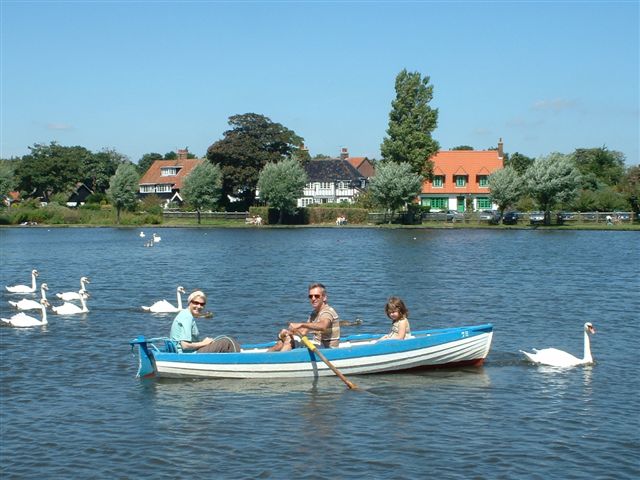
Rowers on the Meare


SIZEWELL is two miles to the north of Thorpeness but only the south of the village is within the parish and includes the large estate houses like Sizewell Hall. There is also a Camping and Caravan park. Fishing with line and rod off the beach continues to be a popular activity and is dog friendly all year round. In the past the area was a favourite spot with smugglers landing large amounts of brandy and lace and other contraband.
 
Sizwell Beach
Sizewell Hall


Copyright © 2023, Aldringham-cum-Thorpe

Feedback Privacy Policy & Use of Cookies OneSuffolk website

By using our website you are consenting to our use of cookies. If you would like to know how we use our cookies or how you can block cookies in your browser please click on our cookie policy.